7th August 2016. Destination: Leglerhütte SAC 2273 m Distance: ca. 12 km Elevation: ca. 920m Time: ca. 7:30:00 Starting: Mettmenalp – 920m
Leglerhütte is my favourite hiking destination. I am not sure what’s the mountain called but Leglerhütte is actually a little cabin on the peak of that mountain. The cabin serves as a restaurant and also rooms for rent. It is the most beautiful hiking spot. Back in 2015, Leglerhütte was my first hiking trip. I remember it clearly as the way up was bearable for a first timer and the last est. 300 meter towards the cabin felt like forever. During that hike, we had lunch behind the cabin because the restaurant was full. We found a hidden spot overlooking the most beautiful lake eating lunch and watching hikers. On the way back, we took a different killing route. It was vigorous. I felt the mountains were deceiving and playing a prank on us. We were going downhill and uphill several times and it did not seem like we were any nearer to the end. That week after the hike, my legs hurt so much I hardly could walk especially the stairs. I am not exaggerating. Herr Hallo could testify.
Ironically, Leglerhütte remains fondly in my heart. Even though it tried to defeat me the first time, I wanted to conquer it again and again. So, in 2016 I suggested to father-in-law and my husband that we should go hike there again. So we did.

Stausee Garichti at MettmenAlp
Our starting point.

Mettmenalp to Leglerhütte
map from map.geo.admin.ch
We departed from our apartment at 06:00. As usual we stopped by Marché Glarnerland for breakfast before our hike if we are heading towards Glarus. There is something that is consistent at Marché Glarnerland. It is consistently windy – at any day and season. The moment you get out of the car, the wind blows strongly on your face and sends chill through your bones. Brr!
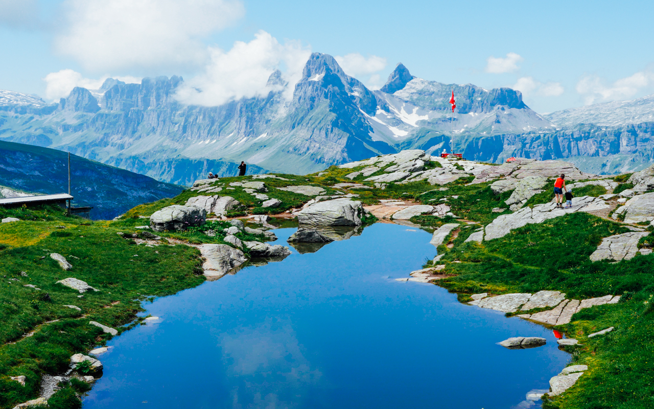
To get to Leglerhütte, we have to take a cable car at Kies-Mettmen. The cable car runs every 30 minutes and we took one at 08:00 to Mettmenalp which sits at ca. 1600 meter above sea level – our starting point. At Mettmenalp, there is a beautiful water reservoir called Stausee Garichti. The water was so clear and calm it is a paradise on its own. This time we decided to take a the opposite way of one we took in 2015.
The first part of the hike was steep. 200 meter and what seemed like elevation at 70 degree. Herr Hallo Snr. (my father in law) was leading the way. He was fast and I had a hard time catching up with him. My heart rate was up the roof and I was eating Dextro (glucose in cubes) like my life depends on it. After every short hike, I have to stop to catch my breath and re-hydrate. I had Ovo-sport and Dextro in my pockets on standby. These snacks help get my mind off the tiredness. It’s quite similar to people eating when their depressed. I eat when I am tired. Food acts as a distraction for me.
Along the way, we met a herd of cows which are a common sights in the mountains. Farmers leave their cows out in the mountains during day time to graze grass and lead them back to the cowshed before sunset. Cows usually pose no danger but we should still take precaution especially if we see mother cow and calves nearby. Although the cows moo-ed at us, we carefully make our way passed them.

A common sight in the Swiss Alps

100% Natural
Lake, Mountains and Skies
After hours of walking and several snack stops, we passed by a small pond (picture on left) overlooking the mountains. There is really something attractive about water in the mountains, isn’t it? The route we took was a lonely one. We saw almost no hikers along the way. It was not as difficult as the one we did last year but it wass pleasant to be alone surrounded by nature. We continued our journey and found a spot for pre-lunch at around 11:00.
A few hundred meters from our pre-lunch spot, there lies a cowshed which is surrounded by what looked like a mixture of mud and cow dung. The cowshed was also secure with electrical wire fence . We were looking for a way around the shed but there was none so we had to go through the shed. At that moment, I could not decide what scare me more – electrocute by the fence or fall in the mud-shit. Both were equally terrible. Luckily we made pass the cowshed with no accidents. Only mud-shit on our boots.
At 12:00, we finally reached an intersection where more hikers can be seen. After this intersection, comes the last part before reaching Leglerhütte. According to the map, the elevation is only 163 meter. This part of the hike is like the trail of death. This part of the route is a stone trail where you are basically hiking on stones. So, let’s imagine you are climbing 163 meter stairs, each step is about 20-30cm.

Leader of the wolfpack.
Herr Hallo Snr.
A few metres after the trail of death, you will come to an edge where you could see Leglerhütte (picture on right). At this point, my tiredness would miraculously disappear. This view is one of the reason why Leglerhütte remains as one of my favourite place in Switzerland. And I know it’s not hard for you to understand. We stopped by the restaurant for our lunch. This time there were seats for us. We ordered a platter of cut meat, bread and cheeses and downed them with beers. Actually, I regretted ordering that after I saw what the couple on our next table were eating. They were having the most delicious looking cake/tart with cream and I wished I ordered that instead.
After lunch & done taking photographs at around 14:00, we headed down to Mettmenalp through Chärpfbrugg where a river runs. Although descending is not as hard as ascending, it hurts our knees very much. Halfway through descending, I would sometimes lose control of my balance because my legs grew weak and rubbery. On the way down, we made a few stops. Finding a shaded spot for rest can be challenging. If you are lucky, you may find human feces behind the spot, as we did! LOL. Nothing to make a fuss about. Move on and find another spot then!
We made our descend fairly quickly because we don’t want to miss the last cable car down. We reached the cable car station a little after 16:30 and managed to catch the last cable car at 17:00. That makes our hiking duration of 8 hours with lunch and plenty of snack stops in between.
Till next post!
x Frau Hallo

Leglerhütte
We made it! At the sight of this, all the hard work was worth it.

Sitting on the edge, literally.
Herr Hallo Snr. leading the way.

Herr Hallo vs. the mountains

My love.

Father and Son.
A short rest before the last leg towards Leglerhütte.

A little lake on the opposite side of Leglerhütte
Note: The lake might be Milchspülersee but we are unsure.

Stausee Garichti
The sight of Stausee Garichti is a relieve. It means the end of the hike is near!
Let us know your thoughts!